
Princeton Planning and Zoning paused a rezoning request for 1503 Longneck Road Monday night, opting to wait for flood, traffic, and topographical studies before deciding whether to recommend the case forward.
Running short on time? Scroll down to The Quick Read for the short version of the story.
A rezoning request for 1503 Longneck Road came before the Princeton Planning and Zoning Commission on Monday, March 16, where commissioners considered whether to recommend that City Council approve changing the property from Single Family Estate (SF E) to Planned Development 46 (PD 46). The tract is about 1.00 acre, and the stated goal is to allow a small office building on the site.
On the surface, that may sound simple. A small office. A one acre tract. A recommendation vote, not final approval.
But once you get into the packet, the core issue shifts. The question is no longer just whether Princeton can handle another office building in the abstract. The real question is whether this particular site is being pushed forward for rezoning before the public has a full and current picture of what the floodplain and drainage conditions actually look like on the ground.
That is where this story changes.
Update, March 16: After discussion Monday night, the Planning and Zoning Commission did not move forward with a recommendation for approval. Instead, the item was held so additional information can be developed, including a flood study, traffic study, and topographical review. The case is expected to return around April 20, when that information is available.
The Quick Read
Princeton Planning and Zoning reviewed a request Monday, March 16, to rezone 1503 Longneck Road from SF E to PD 46 so a small office building can be built on the roughly 1 acre property.
The use itself is fairly limited, and city staff recommended approval. Staff said the area’s future land use supports some neighborhood serving commercial, and PD 46 already cuts out several higher impact uses.
The bigger concern was the site. City documents said part of the property touches flood related areas, including a smaller portion in Zone AE, the 100 year floodplain, and that a flood study would still be required before construction. The packet also said more drainage work, traffic review, tree review, platting, and site development steps would still come later.
That did not automatically mean the project should be denied. But it did leave a key question: was the city being asked to move the zoning forward before the floodplain and drainage picture was fully documented in the public record?
Monday night, the commission did not move the rezoning forward. Instead, members held the item until additional studies can be completed, including flood, traffic, and topographical work. The project is expected to return around April 20 with more of the site reality on record.
Former Planning and Zoning chair Kevin Hiss also raised broader concerns during the public hearing about drainage conditions in the area and later shared additional materials with The Princeton Journal arguing that stormwater infrastructure in the corridor may already be undersized. Those claims add to the pressure on the city and applicant to come back with clearer answers next month.
What the city was asking P&Z to do
The item was listed as a public hearing. Planning and Zoning was being asked to consider sending a recommendation to City Council on the rezoning request for 1503 Longneck Road from SF E to PD 46.
That matters. P&Z was not giving the final yes or no for the whole project. This was a recommendation step. Still, it was a major step. Once zoning starts moving, momentum starts moving with it.
The city’s staff report said the request was meant to allow a small office building, and staff recommended approval. Staff pointed to the property’s location near Monte Carlo Boulevard, nearby commercial growth, and the city’s future land use map, which places the area in Compact Neighborhood and allows a small amount of neighborhood supporting commercial use.
At first glance, that is not an unreasonable case. The city was not pitching a gas station, a drive through, or some loud, high traffic use. The request was for a small office building, and the proposed PD structure keeps the same general use limits already attached to PD 46.
That is the part of the case working in the applicant’s favor.
What PD 46 actually is
PD 46 already exists. It is not brand new. The original ordinance used C 2 General Commercial as the base zoning and then cut out several higher impact uses. In both the existing PD 46 ordinance and the draft ordinance for the Longneck tract, the excluded uses include things like a car wash, gas pumps, drive through uses, vape shops, nail salon, coffee shop, and dental office.
So this is not a request to turn the site into wide open commercial. It is a request to fold this one acre tract into a narrower commercial framework the city has already used nearby.
That is important context, and the public should know it.
Still, that does not answer the harder site question.
The issue is not the office. The issue is the site.
The single most important fact in the current record was this:
part of the property is in or near flood related areas, including a smaller portion in Zone AE, the 100 year floodplain, and staff said a flood study would be required before construction can begin.
Read that again.
The city was asking P&Z to recommend rezoning now, while also saying a flood study still had to happen later.
That was the tension at the center of this case.
It did not automatically mean the rezoning should fail. It did not automatically mean the site can never be built on. But it did mean the case became more complicated once you read the full packet.
Because at that point, this was no longer just a land use question. It became a timing question. A confidence question.
How much of the real site picture was actually known now, and how much was being pushed into later engineering phases?
That is exactly where the commission ended up landing Monday night. Rather than recommending approval or denial, members effectively said: bring back the missing site answers first.
What staff said was still coming later
The staff report did not just mention the flood study. It also said the project would still require drainage analysis, traffic analysis, tree survey and mitigation, preliminary plat, and later site development review. Staff also noted that the concept plan attached to the item had not been reviewed for full code compliance and was only meant to show a general layout.
The report also said road improvements or escrow might be required later as part of the project’s obligations.
That is where concern started to build.
A rezoning packet should not be expected to contain every bolt, every curb, every engineering sheet, and every final permit detail. That is not how development works. But there is still a fair line to ask about, especially when floodplain and drainage are involved.
At what point does “those details come later” stop sounding normal and start sounding like the public is being asked to move the zoning first and trust that the hardest site reality will get worked out afterward?
That was the question hanging over this item, and Monday night it appears to have carried real weight.
Princeton’s own code makes this more serious
This is where the issue moves from concern to standard.
Princeton’s zoning code says zoning exists to protect the health, safety, and general welfare of the public and to ensure adequate transportation, water, wastewater, parks, and other public needs are addressed. It is not just about whether a use sounds reasonable on paper. It is also about whether the site and surrounding conditions can actually support it.
The city’s drainage rules are also not vague. They require drainage facilities to be designed large enough to handle runoff from the entire upstream drainage area, not just the tract itself. They also require downstream effects to be studied, and if existing downstream capacity is not enough, then mitigation has to be designed.
The zoning ordinance goes even further. When Planning and Zoning reviews a request, commissioners are specifically allowed to consider the impact on the environment, including floodplain, riparian areas, topography, vegetation, and traffic findings.
That matters here.
Because it means floodplain, drainage, topography, and traffic are not side issues. They are exactly the kinds of issues the commission is supposed to weigh before making a recommendation.
Why this area is already sensitive
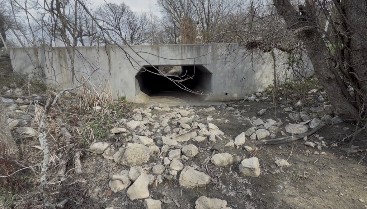
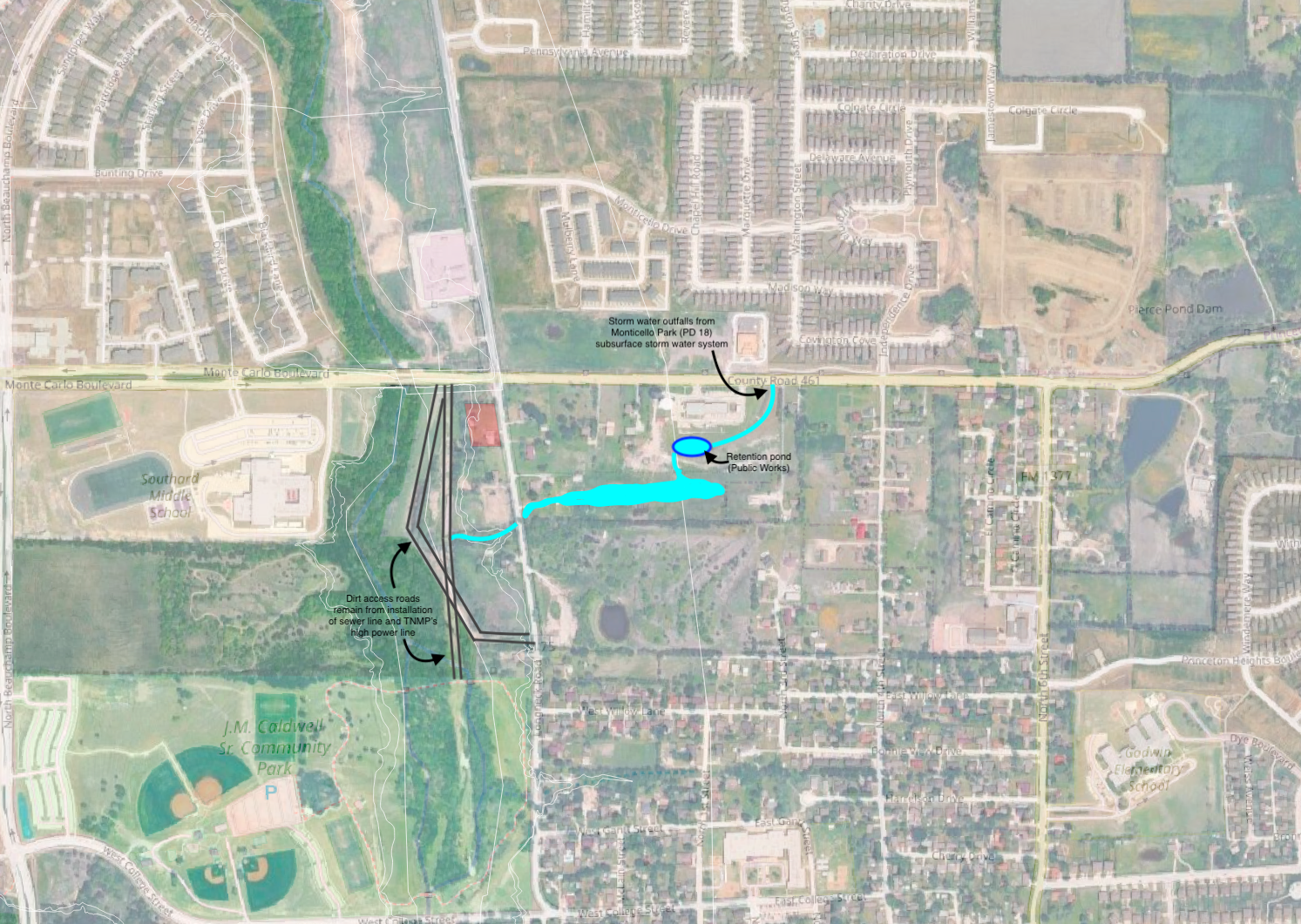
The engineering record also shows that Princeton’s Master Drainage Plan modeled Tickey Creek and identified several major flooding areas and conceptual improvements, including concerns tied to Monte Carlo Boulevard and nearby crossings.
That is a major reason this case got more attention than a standard rezoning.
The Longneck tract is not in some random stable area with no known drainage pressure. It sits in an area where creek conditions, crossings, runoff, and floodplain behavior are already part of the conversation. Staff itself places the tract west of Longneck Road, south of Monte Carlo, and near Caldwell Park.
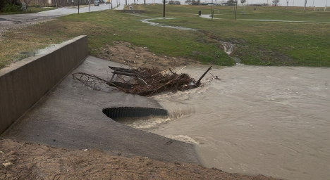
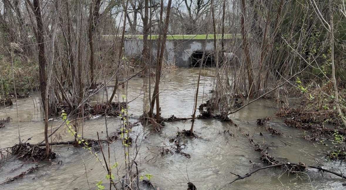
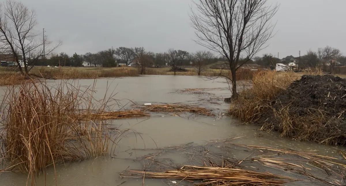
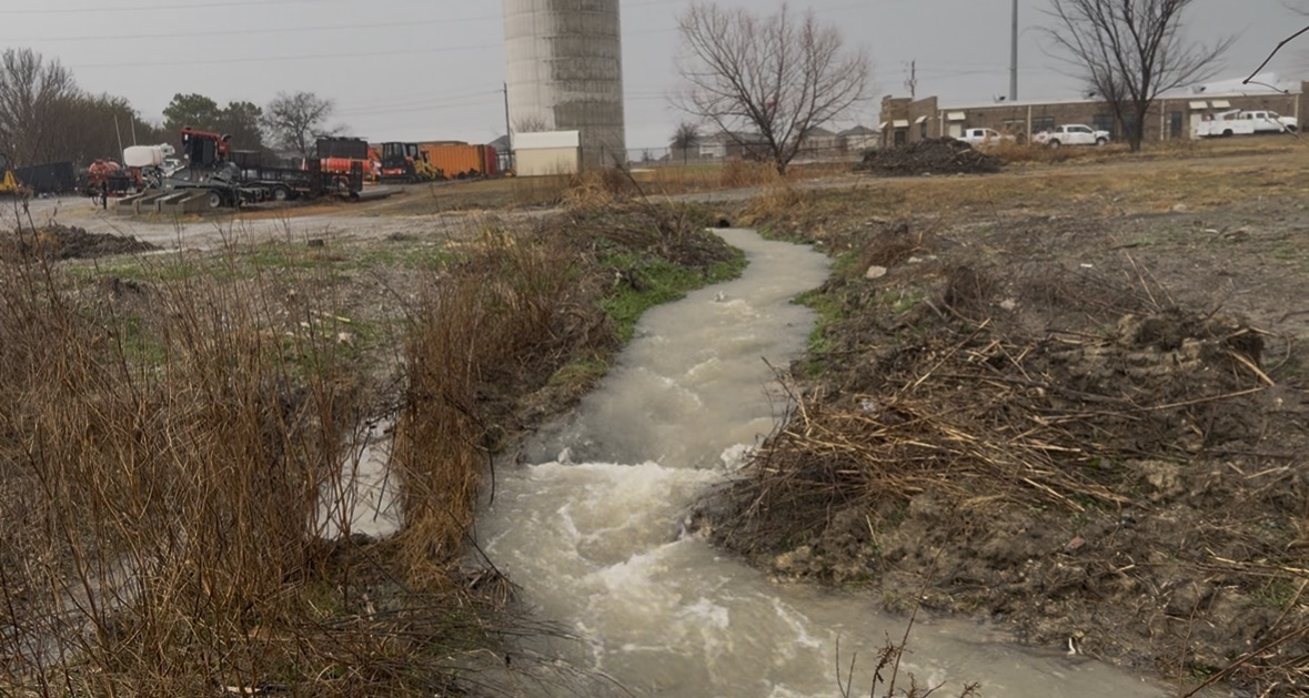
Recent photos circulating in connection with the case show water movement and surface flooding in the general area during rain events. Those images do not prove every legal claim people are making. They do not by themselves prove that this applicant caused any problem, or that a nearby project was unlawful, or that the city would definitely face liability.
But they do reinforce one clear point:
drainage out there is not a side issue.
It is central.
Additional concerns raised by former P&Z chair Kevin Hiss
During the public hearing, former Planning and Zoning chair Kevin Hiss spoke at length about drainage conditions in the area.
After the meeting, Hiss also shared additional materials with The Princeton Journal describing what he says is a broader stormwater problem involving runoff, blocked flow paths, undersized culverts, and worsening flooding conditions near Longneck, Monte Carlo, Public Works, and Tickey Creek.
Among other things, Hiss alleged that upstream development has increased downstream flooding pressure, that certain access roads and infrastructure may be obstructing natural drainage patterns, and that some existing drainage design in the area may be inadequate for current conditions.
Those are serious claims.
At the same time, they should be understood for what they are at this stage: attributed allegations and technical concerns raised by a former official, not final legal findings by the city or a court.
Still, his broader point lines up with why the commission slowed the item down Monday night. If the surrounding corridor is already under drainage stress, then site level questions become even more important, not less.
What is known, and what is not
This is where the public conversation needs to stay disciplined.
What is known
The property is about 1.00 acre.
The request is to rezone from SF E to PD 46.
The proposed use is a small office building.
The city says the area’s future land use category can support some neighborhood serving commercial.
The city also says part of the site touches flood related areas, including a smaller portion in Zone AE, and that a flood study is still required before construction.
The attached concept plan has not been reviewed for full code compliance yet.
Road improvement or escrow obligations may still come later.
And now one more thing is known: the commission did not move the rezoning forward Monday night. Instead, it chose to wait for more information.
What is not yet known from the current public record
The public record still does not show the final flood study.
It still does not fully answer whether the site can meet the city’s drainage standards without pushing more water onto nearby property.
It still does not provide a final road escrow amount in the packet.
It still does not settle every tree, platting, traffic, or site compliance issue.
It still does not fully answer whether current drainage assumptions reflect all nearby changes on the ground.
And while Hiss has now raised broader concerns about the surrounding system, those claims also remain untested in any formal city finding tied to this case.
That does not prove the project fails.
But it also means the public is not crazy for saying the file still feels incomplete where it matters most.
What happened Monday night
After discussion, the commission focused heavily on whether enough was known about the site’s floodplain, drainage, traffic, and topography to justify moving the rezoning forward.
Instead of recommending approval or denial, the commission held the item until additional studies are completed. Those studies are expected to include a flood study, traffic study, and topographical work, with the case likely returning around April 20.
That changes the posture of the case in a major way.
The process has now shifted from assumption to verification.
Instead of moving the zoning first and sorting out the hardest site questions later, the commission is now requiring those questions to be better answered before it decides whether to recommend the case forward.
The argument for approval
There is a real one.
Supporters can fairly say the project is limited in size, limited in intensity, and better than many other commercial options. They can point out that PD 46 cuts out more disruptive uses and that the city’s future land use plan already envisions some neighborhood level commercial in the area. They can also say later engineering review exists for a reason, and that not every technical issue has to be solved at the rezoning stage.
That is a legitimate position.
The argument against recommending it now
This was also real.
Opponents could fairly say that when a site already sits next to known floodplain and drainage concerns, and when staff itself admits that a flood study still has to happen later, it is reasonable to ask why the zoning recommendation should move now before that picture is fully clear.
Now, after Monday’s hearing, that argument has become even broader. It is no longer just about this one acre tract in isolation. It is also about whether the surrounding drainage system is already carrying more pressure than the city is publicly acknowledging.
That is not a proven conclusion yet. But it is clearly part of the public controversy now.
That was the heart of the case against approval.
Not “never.”
Not “no office building ever.”
Not “all development is bad.”
Just this:
why recommend the rezoning before the flood and drainage picture feels fully real, current, and resolved?
That is a serious question. And Monday night, it was serious enough to stop the item from moving forward.
This was not really a fight over whether a small office is evil. It was a fight over whether the city had shown enough, early enough, to justify moving the zoning forward.
What residents should watch next
The next key date is expected to be April 20, when the item may return with more of the site data on record.
When it comes back, residents should watch whether city staff and the applicant can clearly explain:
what part of the site is actually in Zone AE,
what the flood study concludes,
whether drainage impacts on nearby property have actually been tested,
what the traffic study shows,
what the topographical review changes or confirms,
what protections the city has if later engineering gets harder or more expensive,
whether the new material truly resolves the site questions that stalled the case Monday night,
and whether the city addresses any of the broader drainage concerns now being raised about the surrounding corridor.
If the answers are clear, detailed, and grounded, that will matter.
If the answers still drift toward “that comes later,” that will matter too.
Because by that point, the public will have a much clearer answer about what this vote really is.
A recommendation built on evidence.
Or another delay driven by uncertainty.
The bottom line
The Longneck rezoning is not a cartoon villain story. It is more complicated than that. The project itself is modest. The use is narrower than standard commercial. The land use case is not absurd.
But the site questions are not fully resolved, and the file was not complete where the public had the strongest reason to care.
Princeton’s own drainage rules require upstream runoff to be accounted for and downstream impacts to be addressed. The city’s own packet said the flood study still had to happen later. And Monday night, the commission decided those missing answers mattered enough to pause the case rather than rush it forward.
Now, with additional drainage concerns being raised publicly by a former Planning and Zoning chair, the pressure for a clearer, more fully documented record has only grown.
The public does not need panic.
It needs clarity.
And on Monday night, Princeton Planning and Zoning made one thing clear: before this case moves forward, the city wants more of the site reality on the table.